Geographical barriers to services sub-domain
Geographical Barriers to Services is a sub-domain of the Barriers to Housing and Services domain, which is one of the domains that make up the Index of Multiple Deprivation 2019 (IMD 2019).
Key points
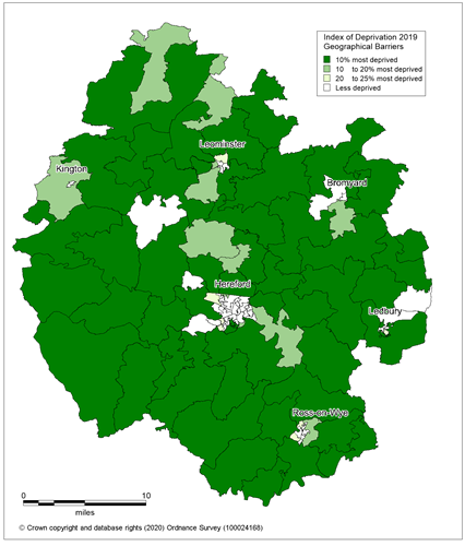
Physical distance from services and facilities presents a problem in rural areas such as Herefordshire and as such the geographical barriers sub-domain has a very different pattern across the county to the other domains of deprivation.
Almost two thirds of all Herefordshire LSOAs [1] (72 of the 116) are among the 25% most deprived in England in respect to geographical barriers to services with 53 being in the most deprived 10% across England.
Of these deprived 72 LSOAs three quarters are in rural areas.
In contrast there are just eight Herefordshire LSOAs among the 25% least deprived in England, five of which are in north Hereford and one each in south Hereford, Ledbury and Kington.
The Geographical Barriers to Services sub-domain relates to the physical proximity of local services and is made up of the following indicators –
- Road distance to a post office: A measure of the mean distance to the closest post office for people living in the Lower-layer Super Output Area
- Road distance to a primary school: A measure of the mean distance to the closest primary school for people living in the Lower-layer Super Output Area
- Road distance to a general store or supermarket: A measure of the mean distance to the closest supermarket or general store for people living in the Lower-layer Super Output Area
- Road distance to a GP surgery: A measure of the mean distance to the closest GP surgery for people living in the Lower-layer Super Output Area
Figure 1: Map showing the areas of Herefordshire that are amongst the most deprived in England according to the Geographical Barriers to Services sub-domain of the IMD 2019.
Source: Ministry of Housing, Communities and Local Government[1]Lower Super Output Areas (LSOAs) are fixed statistical geographies of about 1,500 people designed by the Office for National Statistics (ONS). For more information please see the useful definitions page.